Project Highlights | |
|---|---|
| Location | Northern Saskatchewan, Canada. |
| Ownership | Under Option, Aero Energy (TSXV: AERO) can earn up to 70% over 3.5 years. |
| Status | Athabasca Basin uranium exploration projects with >40 km of prospective buried graphitic EM conductors with drill grades up to 13.8% U3O8. Exploration is actively ongoing, with a drill program expected to commence in summer. |
Projects Summary
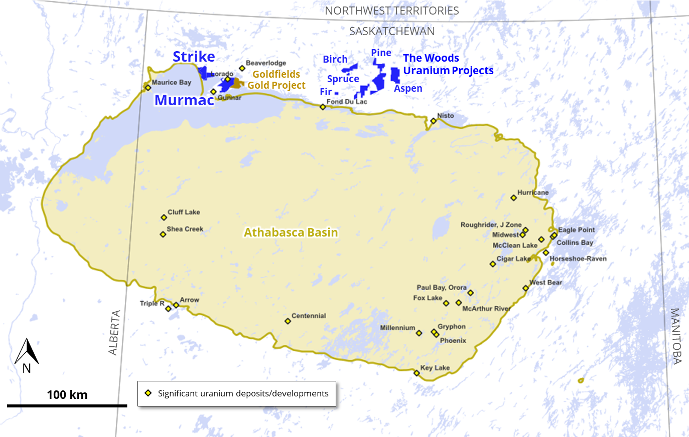
The Murmac and Strike Projects comprise 21 mineral claims covering an area of approximately 20,000 hectares located within 25 km of Uranium City in Northern Saskatchewan, Canada, on the northern rim of the Athabasca Basin. The Project is endowed with established infrastructure including existing roads, active hydro-powerline, and nearby facilities and an airport at Uranium City.
Work at the Projects is currently being funded by Aero Energy under an Option Agreement, executed on December 15, 2023, that provides for a 70% earn-in subject to exploration expenditure of C$6 million over a 3.5 year time period.
The Projects host over 40 km of previously underexplored prospective buried graphitic electromagnetic (“EM”) conductors, the typical host rocks for high-grade unconformity-related, basement-hosted uranium deposits in a geological setting similar to other discoveries on the margin of the Athabasca Basin.
Exploration activities to date by Fortune Bay have included compilation of historical exploration work, high resolution VTEMTM electromagnetic and magnetic geophysical survey, ground gravity survey, surface prospecting, radon gas in water survey, and exploration drilling, targeting a combination of geophysical, structural and geological targets. The results from exploration drilling confirm that an Athabasca Basin unconformity-style mineralizing system has been active in both Project areas, with grades up to 13.8% U3O8 reported hosted in structured graphitic rocks. Follow-up of intersected mineralization is warranted, as well as ongoing drill testing of numerous geophysical and structural targets.
Murmac and Strike Projects Location
Drilling Results
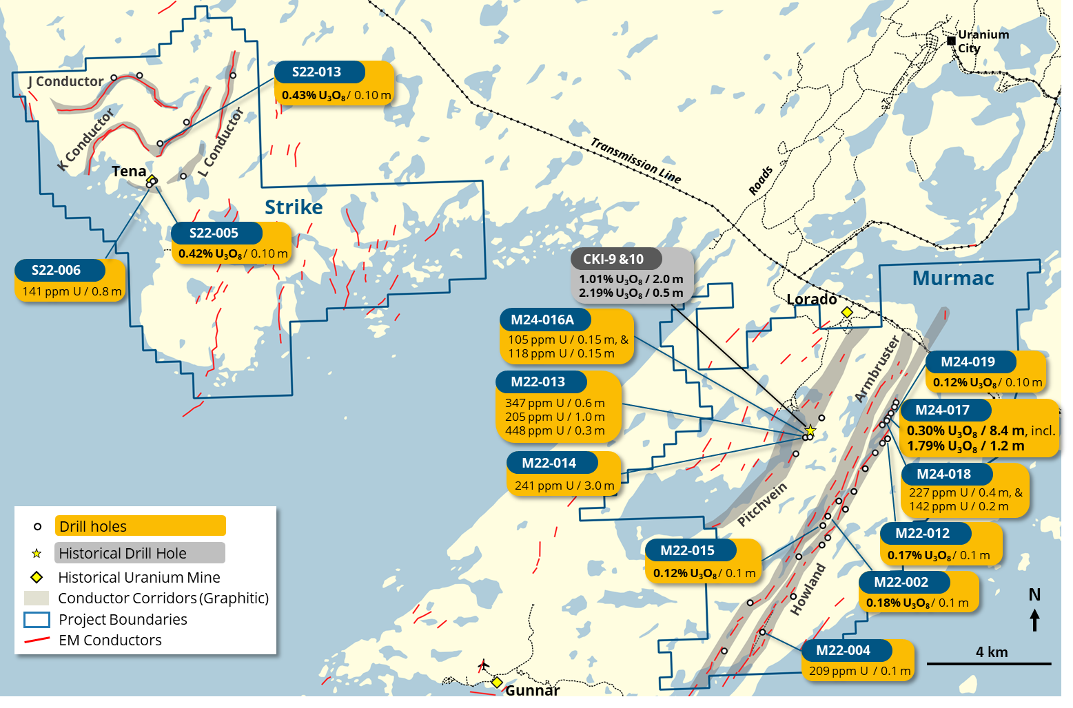
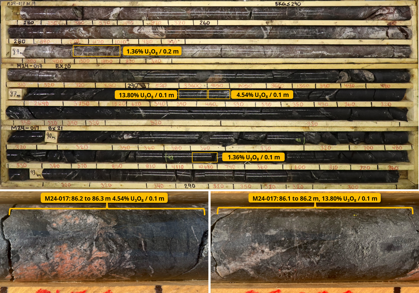
Fortune Bay has completed 36 core holes (7,654 m) to date. Drilling, exclusively targeting the defined electromagnetic (“EM”) conductors, has tested a variety of geophysical, structural and geological targets. The most encouraging drill result to date derived from this approach is an intercept at Murmac of 0.3% U3O8 over 8.4 m with individual assay grades up to 13.8% U3O8 (drill hole M24-017, core photographs shown below), clearly indicating that an Athabasca Basin unconformity-style mineralizing system has been active along the targeted graphitic units. The intersection was hosted in favorable structured graphitic rocks at their intersection with a pronounced cross fault. Down-dip and along strike follow-up at this location returned anomalous uranium in several holes, indicating the presence of a larger mineralizing system and highlighting the potential of this EM conductor for a meaningful discovery. Anomalous uranium (defined as >100 ppm U) has been intercepted in 13 of the 32 holes for which geochemical results are available (results from four holes completed in winter 2025 are not yet available).
Murmac Summary of Drilling and Highlight Drill Results
Summary of Anomalous (>100 ppm U / >0.01% U3O8) Results from Fortune Bay Drilling

Notes:
- Uranium concentration in parts per million (“ppm”) are shown as determined through partial digest ICP OES or ICP-MS analysis on all samples, as described in the technical disclosure below.
- Uranium content as weight % U3O8 was determined for samples with > 1,000 ppm U through digestion in a concentration of HCl:HNO3, and ICP-OES analysis. For samples < 1,000 ppm U, the weight % U3O8 was calculated empirically from the U ppm value.
- True thicknesses of the drill core intersections are yet to be determined.
- Results from 4 holes completed in winter 2025 at Murmac are not yet available.
M24-017 drill core photos. Hangingwall hematized quartzite overlying structured graphitic pelite, hosting uranium mineralization up to 13.8% U3O8 within a larger interval of 0.3% U3O8 over 8.4 m.
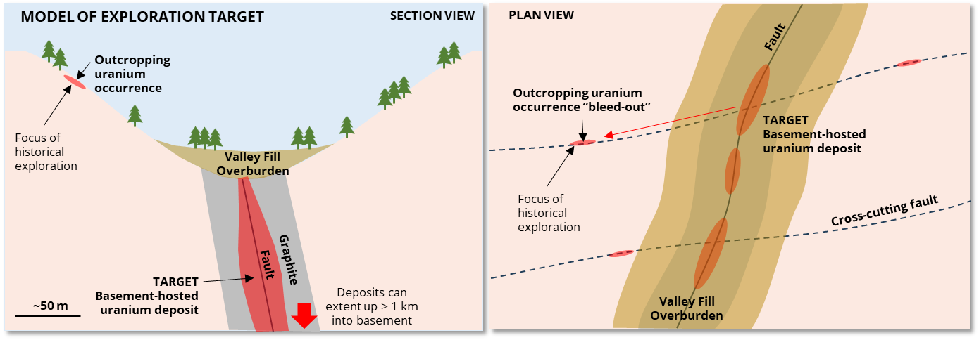
Exploration Potential – a Validated Exploration Model
Historical exploration at Murmac and Strike focussed overwhelmingly on surface prospecting of exposed outcrop, targeting Beaverlodge-type deposits in outcropping granitic rocks. The Projects combined host >40 km strike length of prospective electromagnetic (“EM”) conductors (graphite- and sulphide-rich lithological units), which are typically soft and weather preferentially, forming pronounced steep-sided negative topographical features (valleys) infilled with cover sediments and lakes. The prospective conductors are not visible at surface and have never been systematically explored, despite them being the preferred hosts for Athabasca Basin high-grade uranium deposits.
Murmac and Strike Validated Exploration Model
The geological setting, historical datasets and current drill results support the Project’s potential for Athabasca Basin high-grade unconformity-related, basement-hosted uranium deposits in accordance with current exploration models for these types of deposits, with key exploration criteria identified below:
Significant Uranium Endowment
- Located between past producers, the Gunnar Mine (18M lbs U3O8) the south and the Beaverlodge/Lorado Mines to the north (combined 50M lbs U3O8).
- Numerous historical high-grade (> 1% U3O8) uranium occurrences comprising fault-hosted mineralization occurring in outcrop and boulders, within the Project Area.
Favorable Host Rocks
- Three main EM conductor packages (Armbruster, Howland and Pitchvein) covering a combined strike length of over 30 km. These conductors have been confirmed to represent graphite-rich metasediments, which are known to provide favorable settings for the formation of Athabasca Basin high-grade, unconformity-related deposits.
- Abundant quartzites (highly resistant) are present along the strike of and in contact with the conductive units (very soft), providing favorable competency contrasts to create prospective dilational settings.
- The Athabasca Basin margin is located approximately five kilometres to the south of the Project, indicating vertical proximity to the basal unconformity (now eroded) and good preservation potential for basement-hosted mineralization. The basal unconformity of the Martin Group transects the northern part of the Project.
Sampling, Analysis and Data Verification
All drilling was carried out with NQ2 diameter core. The oriented drill cores have been subjected to comprehensive logging and sampling to characterize mineralization, alteration and structure. Sample intervals range from 10 to 135 cm.
Half-split drill core samples were submitted to the Saskatchewan Research Council (“SRC”) Geoanalytical Laboratories (ISO/IEC 17025:2005 accredited) for uranium assay and multi-element characterization. Samples are screened upon receipt by SRC, and samples with significantly elevated radioactivity are identified and separated out for the SRC “ICP1” multi-element uranium exploration package, with an additional assay for U3O8 in weight percentage where uranium content exceeds a 1000 ppm threshold. Analysis of the remaining samples was carried out through the SRC “ICP-MS2” basement exploration package.
Sample preparation for all samples includes drying, jaw crushing to 60% passing -2 mm, and pulverizing to 90% passing -106 microns. The ICP1 package includes ICP-OES on a total digestion and ICP-MS on a partial digestion, with U3O8 assay carried out by partial digestion and analysis by ICP-OES. The ICP-MS2 package consists of three separate analyses, including (1) ICP-MS on a partial digestion, (2) ICP-OES for major and minor elements on a total digestion and (3) and ICP-MS analysis for trace elements on the total digestion. Partial digestions are performed using HNO3:HCl. Total digestions are performed using a mixture of concentrated HF:HNO3:HClO4. Additional analysis for Boron content was obtained for all samples through NaO2/NaCO3 fusion followed by ICP-OES.
QAQC for sample processing included insertion of Blank certified reference material (“CRM”) samples by Fortune Bay at a rate of 1 for every 20 samples, as well as an internal QAQC process by SRC, including regular repeat analyses and insertion of CRM multi-element, uranium and boron standards. All QAQC results were reviewed by Fortune Bay and are considered to confirm that the analyses are of high quality and are sufficiently well constrained to use for the purpose of exploration.
Technical Disclosure
The historical exploration information presented here has been compiled from reports obtained from the Saskatchewan Mineral Assessment Database. Unless otherwise stated, the historical results have not been verified and there is a risk that any future confirmation work and exploration may produce results that substantially differ from the historical results. The Company considers these results relevant to assess the mineralization and economic potential of the property. The historical drill results obtained by SMDC in drill holes CKI-9 and CKI-10 can be found within the SMAD references 74N07-0310 and 74N07-0311 and have not been verified.
Qualified Person
The technical and scientific information on this webpage has been reviewed and approved by Gareth Garlick, P.Geo., Technical Director of the Company, who is a Qualified Person as defined by NI 43-101. Mr. Garlick is an employee of Fortune Bay and is not independent of the Company under NI 43-101.
Cautionary Statements
Information set forth on this webpage may contain forward-looking statements that are based on assumptions as of the date of posting. The reader is referred to the cautionary language contained within the respective Project’s News Releases, in addition to this website’s Terms of Use specifically including Forward Looking Statements.