Fortune Bay Intersects Elevated Radioactivity in Maiden Drill Program at the Strike Uranium Project
HALIFAX, NS June 28, 2022 – Fortune Bay Corp. (TSXV:FOR, FWB:5QN, OTCQX: FTBYF) (“Fortune Bay” or the “Company”) is pleased to announce initial drill results for its 100% owned Strike Uranium Project (“Strike” or the “Project”), located in northern Saskatchewan (see Figures 1 and 2). A total of nine drill holes were completed comprising 2,064 metres. Results included shallow intersections of elevated radioactivity, between 35 and 95 metres below surface, within favorable geological settings for high-grade, basement hosted deposits typical of the Athabasca Basin.
Highlights:
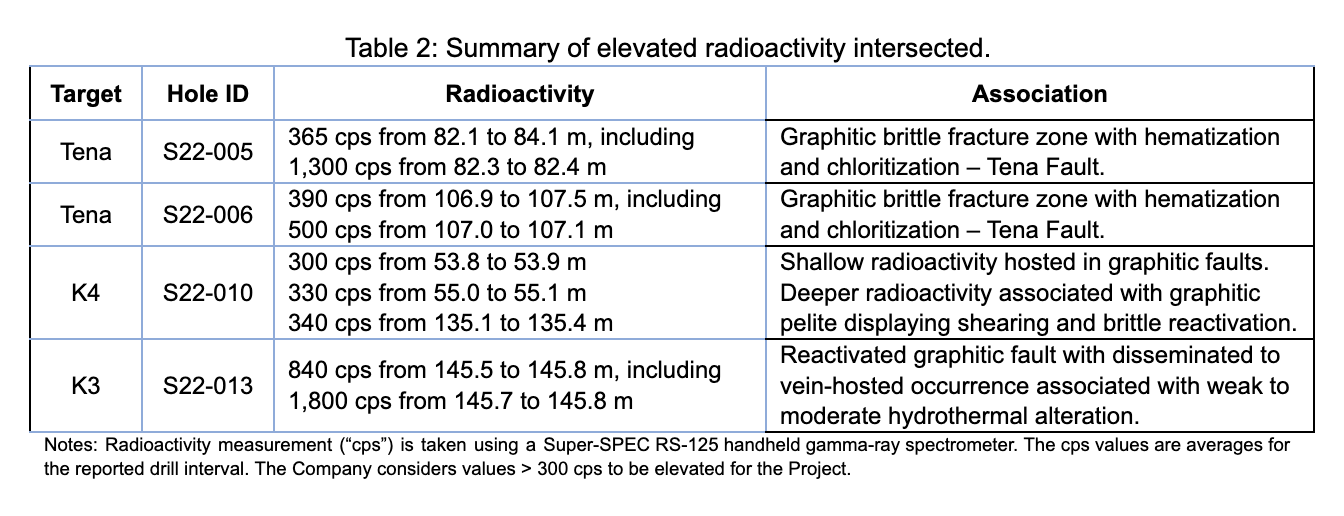
- Elevated radioactivity of over 300 counts per second (“cps”) was intersected in four of the nine drill holes completed (Table 2). The elevated radioactivity was associated with prospective graphitic faults and favorable hydrothermal alteration:
- Drill hole S22-013 (K3 target) intersected an average of 840 cps from 145.5 to 145.8 metres (approximately 90 metres below surface), including 1,800 cps from 145.7 to 145.8 metres.
- Drill hole S22-005 (Tena target) intersected an average of 365 cps from 82.1 to 84.1 metres (approximately 70 metres below surface), including 1,300 cps from 82.3 to 82.4 metres.
- Drill hole S22-006 (Tena target) intersected an average of 390 cps from 106.9 to 107.5 metres (approximately 95 metres below surface), including 500 cps from 107.0 to 107.1 metres.
- Drill hole S22-010 (K4 target) intersected 300 cps from 53.8 to 53.9 metres and 330 cps from 55.0 to 55.1 metres (both approximately 35 metres below surface). These shallow intersections conform with a new discovery of radioactive showings on surface with radioactivity of up to 5,000 cps. An average of 340 cps was also intersected from 135.1 to 135.4 metres (approximately 80 metres below surface).
- Drill hole S22-013 and S22-010 are located approximately 1.1 kilometres apart along the same graphitic unit (K-conductor), defining a trend for follow-up. Nearby historical surface grab samples include HY080 1.51% U3O8, Stancliff 0.19% U3O8, and Hacker Atompower 0.13% U3O8 (see Figure 3).
Dale Verran, CEO for Fortune Bay, commented, “We are very pleased with the initial results from the maiden exploration drilling program at the Strike Uranium Project. This was the first drill program aimed at testing the extensive electromagnetic conductors on the project at shallow depths, and the results have identified the key ingredients for high-grade, basement-hosted discoveries related to the Athabasca Basin. The intersection of elevated radioactivity and favorable alteration, associated with prospective graphitic structures, indicates the presence of a uranium mineralizing system adjacent to the present-day edge of the Athabasca Basin. Our experienced technical team is particularly encouraged by the results from drill hole S22-013 which was highlighted by 1,800 cps within a graphitic fault with hydrothermal alteration, representing a priority area for follow-up along the K-conductor. Laboratory uranium assay and geochemical results, combined with structural analysis of drill core and detailed surface mapping, will be utilized to plan a follow-up program.”
Mr. Verran further added, “Exploration drilling has now commenced at the Murmac Uranium Project where the Company plans to test a compelling set of eight to ten targets identified from electromagnetic and gravity surveying in proximity to numerous radioactive and uranium surface showings and/or favorable structural features. We are looking forward to the continued drilling results from our Strike and Murmac Uranium Projects.”
Strike Drill Results
Drill Program Summary
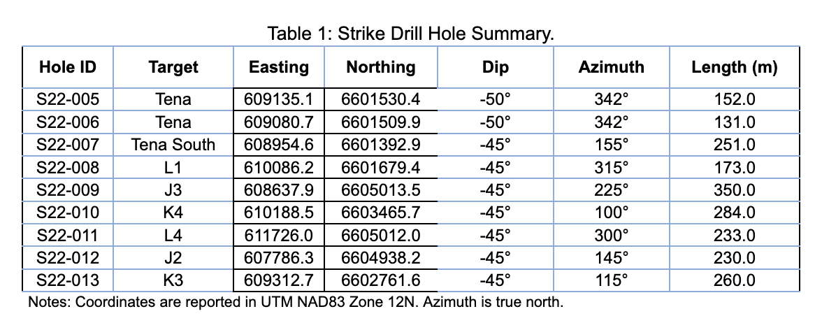
A total of nine drill holes (2,064 metres) were completed during the period May 21 to June 15, 2022. Holes were drilled to test the targets documented in the News Release dated April 26, 2022, which were refined following completion of ground gravity surveying in May. Two holes were drilled at the Tena target, a historical prospect where over 1,000 tonnes of uranium ore were mined in the 1950’s with reported grades of 0.6% to 3.5% U3O8. A third hole was drilled at the Tena South target, a coincident gravity low and electromagnetic (“EM”) conductor immediately south of the Tena prospect. The remaining six holes targeted discrete gravity lows located along prominent EM conductor corridors (named “J”, “K” and “L”) proximal to favourable geochemistry results and structural features. Drill hole collar information is summarized in Table 1 and drill hole locations are shown in Figure 3.
Initial Drill Results
The initial drill results for each drill hole are summarized below, with final drill results to be announced following receipt of uranium assay, geochemical and reflectance data. Radioactivity results are presented as minimum and maximum counts per second (“cps”) recorded within the interval reported, as measured by a Super-SPEC RS-125 handheld gamma-ray spectrometer. A summary of any elevated radioactivity (> 300 cps) encountered is provided in Table 2.
- Drill hole S22-005 (Tena) intersected a mylonitized sequence of semipelitic to pelitic migmatite, diatexite and granite. The Tena fault, a graphitic, brittle fracture zone with hematization and chloritization, was intersected from 82.1 to 85.6 metres. Disseminated to fracture-hosted radioactivity averaging 365 cps (between 250 and 1,300 cps) is intersected from 82.1 to 84.1 metres (see Figure 4).
- Drill hole S22-006 (Tena) intersected a mylonitized sequence of semipelitic to pelitic migmatite and diatexite. The Tena fault, as described above, was intersected from 106.7 to 107.7 metres. Disseminated to fracture-controlled radioactivity averaging 390 cps (between 320 and 500 cps) was intersected in the fault from 106.9 to 107.5 metres. Drill hole S22-006 was a 60 metre step-out west of S22-005.
- Drill hole S22-007 (Tena South) intersected a mylonitized sequence of semipelitic to pelitic migmatite and diatexite with intermittent quartzite units with locally elevated sulphide content explaining the conductor target. No radioactivity above background was observed.
- Drill hole S22-008 (L1) intersected a mylonitic sequence of semipelitic gneiss, granite, and pelitic migmatite. Weakly bleached and clay-altered rock was intersected (88.7 to 91.5 metres) associated with a brittle fault fracture zone (89.3 to 90.0 metres). Sheared graphite- and pyrite-bearing pelitic gneiss was intersected from 125.5 to 136.3 metres with brittle fault reactivation from 134.9 to 135.3 metres. Weak bleaching and clay-coated fractures are associated with the fault zone. No radioactivity above background was observed.
- Drill hole S22-009 (J3) intersected a mylonitized sequence of semipelitic to pelitic migmatite and diatexite with intermittent graphite-bearing pelitic gneiss (104.8 to 197.5 metres). The graphitic units are variably sheared with abundant sulphide and brittle reactivation features. Weak bleaching occurs sporadically in the graphitic shear zones. No radioactivity above background was observed.
- Drill hole S22-010 (K4) intersected a mylonitic sequence of semipelitic to pelitic migmatite and diatexite. Weak bleaching and clay alteration, as well as weakly elevated radioactivity (up to 330 cps from 55.0 to 55.1 metres), occurs locally in a sheared and faulted section from 53.0 to 56.2 metres (see Figure 4). Variably graphitic and pyritic pelitic gneiss occurs between 135.9 to 180.5 metres with abundant shearing and semi-brittle deformation. Local sub-metre scale brittle fault reactivations occur between 138.9 to 149.9 m, from 155.5 to 158.2 metres and 171.9 to 172.4 metres. Weakly elevated radioactivity averaging 340 cps (between 300 and 400 cps) occurs along foliation above the graphitic stratigraphy from 135.1 to 135.4 metres (see Figure 4). The shallower intersection (53.0 to 56.2 metres) conforms with new (not previously documented) radioactive showings discovered at surface while collaring the drill hole. These showings are associated with graphitic fault breccias in granitoid hosts with radioactivity of up to 5,000 cps (see Figure 4).
- Drill hole S22-011 (L4) intersected a mylonitic sequence of psammitic, semipelitic, and pelitic gneiss stratigraphy with interleaved granite and graphite-bearing pelitic gneiss. The dominant graphitic unit was intersected from 127.9 to 149.6 metres. Weak to moderate bleaching occurs from 127.9 to 162.3 metres associated with intermittent metre-scale graphitic faults. Local high sulphide content is associated with sporadic quartz veining. No radioactivity above background was observed.
- Drill hole S22-012 (J2) intersected a mylonitic sequence of semipelitic to pelitic migmatite and diatexite, with variably graphite-bearing pelitic gneiss from 79.6 to 153.1 metres with intermittent graphitic shearing and brittle reactivation. Weak bleaching and clay alteration occurs from 100.5 to 106.0 metres associated with graphitic fault development. No radioactivity above background was observed.
- Drill hole S22-013 (K3) intersected a mylonitic sequence of semipelitic to pelitic migmatite to diatexite, with variably graphite-bearing pelitic gneiss from 110.4 to 147.0 metres. Graphitic shearing and semi-brittle deformation occur from 110.4 to 124.0 metres with a brittle overprint from 122.0 to 124.0 metres. A zone of graphitic shearing and a reactivated graphitic fault with hydrothermal alteration occurs from 143.3 to 147.0 metres and hosts elevated radioactivity averaging 840 cps (between 300 and 1,800 cps) from 145.5 to 145.8 metres (see Figure 4).
Technical Disclosure
All drilling is being carried out with NQ3 or NQ2 diameter. Radioactivity in counts per second (“cps”) has been measured using a Super-SPEC RS-125 Spectrometer. Individual measurements are taken over 0.1 metre core increments, which is the approximate width of the instrument sensor, and averaged over larger intervals where elevated. Core is removed from the core box and moved, if necessary, to a location where the instrument reads below background, and the measurement is collected by placing the sensor against the core at the required location. Background radioactivity is estimated at 200 cps, and values > 300 cps are considered to be elevated. The oriented drill cores are being subjected to comprehensive logging and sampling to characterize mineralization, alteration and structure. Samples will be submitted to the Saskatchewan Research Council (“SRC”) Geoanalytical Laboratories (ISO/IEC 17025:2005 accredited) for uranium assay and multi-element characterization.
Unless otherwise stated, the historical results (including drill results) contained within this news release have not been verified and there is a risk that any future confirmation work and exploration may produce results that substantially differ from the historical results. The Company considers these results relevant to assess the mineralization and economic potential of the property. Further details regarding the historical Tena prospect can be found within the Saskatchewan Mineral Deposit Index (SMDA #1511). Further details regarding the historical surface grab samples from HY080, Stancliff and Hacker Atompower are available within Cameco Corp. assessment reports filed on the Saskatchewan Mineral Assessment Database (SMAD File Number 74N-0102, 74N-0103 and 74N-0106).
Qualified Person and Data Quality
The technical and scientific information in this news release has been reviewed and approved by Dale Verran, M.Sc., P.Geo., Chief Executive Officer of the Company, who is a Qualified Person as defined by NI 43-101. Mr. Verran is an employee of Fortune Bay and is not independent of the Company under NI 43-101.
About Fortune Bay
Fortune Bay Corp. (TSXV:FOR, FWB: 5QN, OTCQX: FTBYF) is an exploration and development company with 100% ownership in two advanced gold exploration projects in Canada, Saskatchewan (Goldfields Project) and Mexico, Chiapas (Ixhuatán Project), both with exploration and development potential. The Company is also advancing the 100% owned Strike and Murmac uranium exploration projects, located near the Goldfields Project, which have high-grade potential typical of the Athabasca Basin. The Company has a goal of building a mid-tier exploration and development Company through the advancement of its existing projects and the strategic acquisition of new projects to create a pipeline of growth opportunities. The Company’s corporate strategy is driven by a Board and Management team with a proven track record of discovery, project development and value creation. Further information on Fortune Bay and its assets can be found on the Company’s website at www.fortunebaycorp.com or by contacting us as info@fortunebaycorp.com or by telephone at 902-334-1919.
On behalf of Fortune Bay Corp.
”Dale Verran”
Chief Executive Officer
902-334-1919
Cautionary Statement Regarding Forward-Looking Information
Information set forth in this news release contains forward-looking statements that are based on assumptions as of the date of this news release. These statements reflect management's current estimates, beliefs, intentions, and expectations. They are not guarantees of future performance. Words such as “expects”, “aims”, “anticipates”, “targets”, “goals”, “projects”, “intends”, “plans”, “believes”, “seeks”, “estimates”, “continues”, “may”, variations of such words, and similar expressions and references to future periods, are intended to identify such forward-looking statements. Fortune Bay Corp. (“Fortune Bay” or the “Company”) cautions that all forward-looking statements are inherently uncertain, and that actual performance may be affected by a number of material factors, many of which are beyond Fortune Bay's control. Such factors include, among other things: risks and uncertainties relating to metal prices, changes in planned work resulting from weather, COVID-19 restrictions, availability of contractors, logistical, technical or other factors, the possibility that results of work will not fulfill expectations and realize the perceived potential of Fortune Bay's mineral properties, uncertainties involved in the interpretation of drilling results and other tests, the possibility that required permits may not be obtained in a timely manner or at all, risk of accidents, equipment breakdowns or other unanticipated difficulties or interruptions, the possibility of cost overruns or unanticipated expenses in work programs, the risk of environmental contamination or damage resulting from the exploration operations, the need to comply with environmental and governmental regulations and the lack of availability of necessary capital, which may not be available to Fortune Bay, acceptable to it or at all. Fortune Bay is subject to the specific risks inherent in the mining business as well as general economic and business conditions. Accordingly, actual, and future events, conditions and results may differ materially from the estimates, beliefs, intentions, and expectations expressed or implied in the forward-looking information. Except as required under applicable securities legislation, Fortune Bay undertakes no obligation to publicly update or revise forward-looking information. Fortune Bay does not intend, and does not assume any obligation, to update these forward-looking statements, except as required under applicable securities legislation. For more information on Fortune Bay, readers should refer to Fortune Bay's website at www.fortunebaycorp.com.
Neither TSX Venture Exchange nor its Regulation Services Provider (as that term is defined in policies of TSX Venture Exchange) accepts responsibility for the adequacy or accuracy of this release.
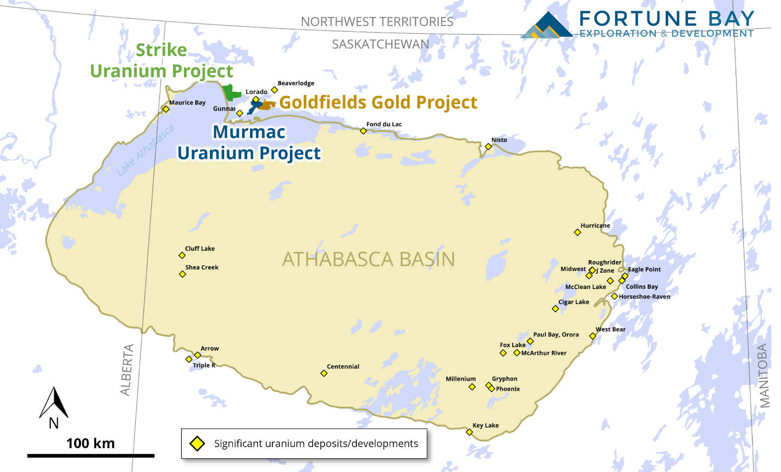
Figure 1: Location of the Goldfields, Strike and Murmac Projects relative to the Athabasca Basin.
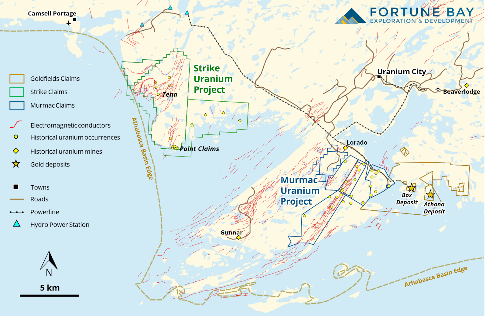
Figure 2: Location of the Goldfields, Strike and Murmac Projects.
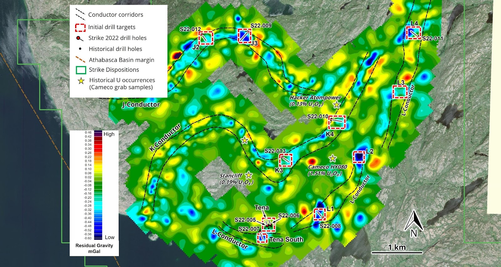
Figure 3: Location of the nine drill holes completed on the Strike Uranium Project.
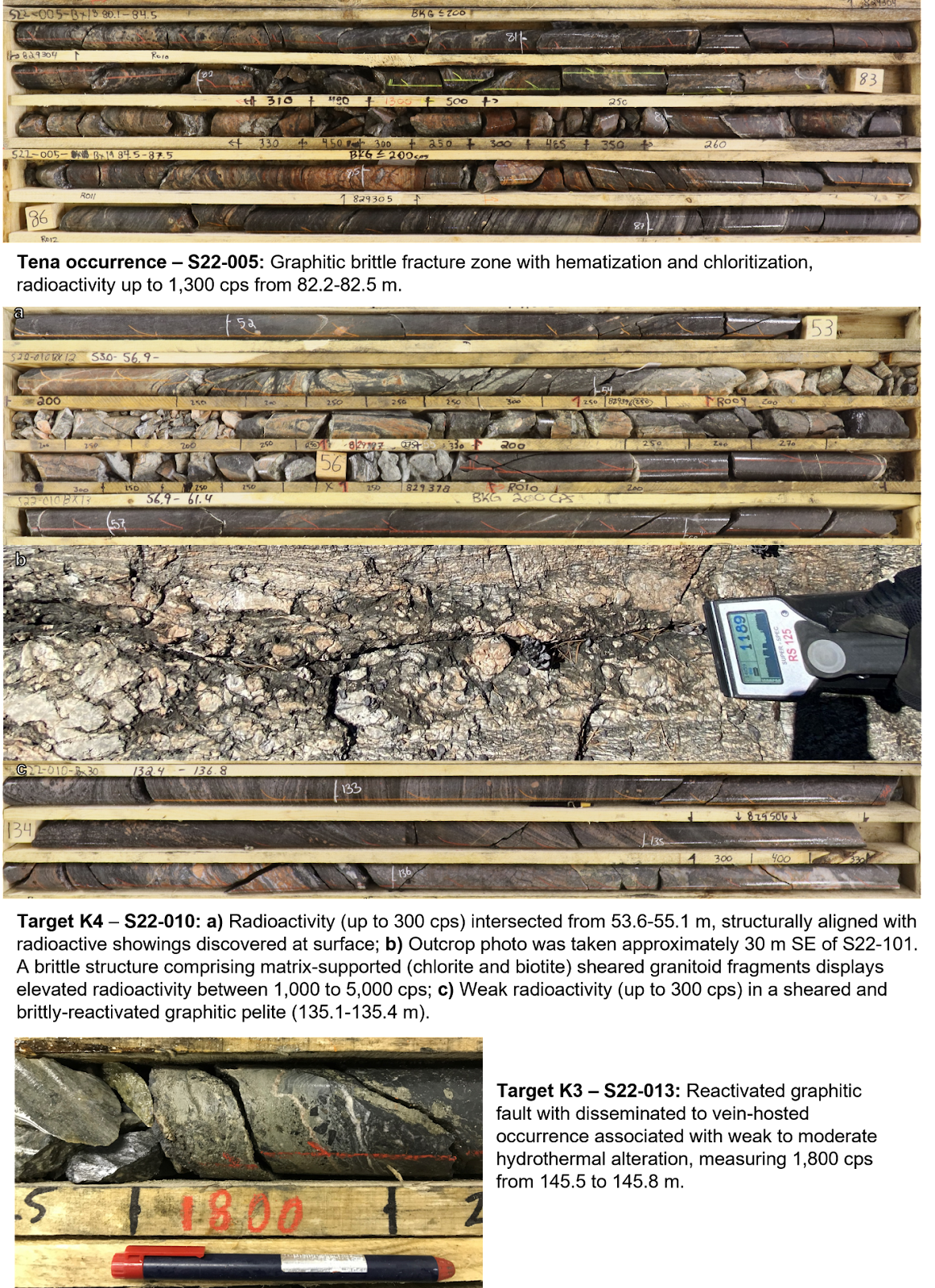
Figure 4. Drill core and outcrop photographs from Strike Uranium Project.