Fortune Bay Announces Exploration Drill Targets for the Goldfields Project and Provides Update on Mineral Resource Estimate
HALIFAX, NS October 13, 2020 – Fortune Bay Corp. (TSXV:FOR, Frankfurt: 5QN) (“Fortune Bay” or the “Company”) is pleased to announce drill targets for its 100% owned Goldfields Project (“Goldfields” or the “Project”) located in northern Saskatchewan. The drill targets have been developed following a detailed review of the Project’s historical exploration and drilling results which demonstrate potential to expand the mineral resources at both the Box and Athona gold deposits, in addition to regional targets on the Property.
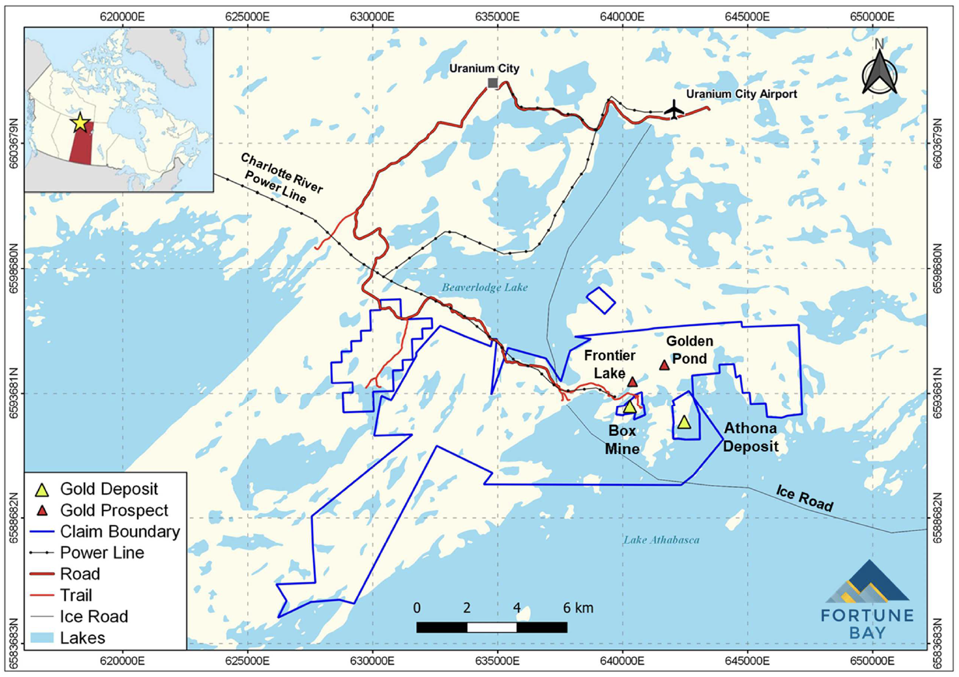
The Company is also pleased to provide an update on the mineral resource estimation process initiated for the Project in August 2020, with the objective of verifying the Box and Athona historical estimates and classifying current mineral resources in accordance with National Instrument 43-101 (“NI 43-101”) (see Fortune Bay’s News Release dated July 28, 2020). A location and infrastructure map for Goldfields is provided in Figure 1.
Dale Verran, CEO for Fortune Bay, commented, “The exploration drill targets identified to date represent an exciting opportunity to expand the mineral resources at both the Box and Athona deposits. Our initial focus will be on step-out drilling from higher-grade zones that remain open, guided by our improved understanding of the structural controls on the mineralization. We are also encouraged by the regional potential to discover additional deposits on the Property though modern, systematic exploration. While the Company awaits a drilling permit for Goldfields, work is also well underway on the updated mineral resource estimate. The field program completed during September was instrumental in advancing verification of the historical data and understanding the nature and controls on gold mineralization, which will form key inputs for the mineral resource estimation process.”
Drill Target Highlights
Box Deposit
- The Box deposit remains open, specifically at depth where meaningful grades and thicknesses have been intersected both outside the boundary of the historical mineral resource estimate, and below the depth of the previous open pit defined in the historical (2011) Pre-Feasibility Study for Box.
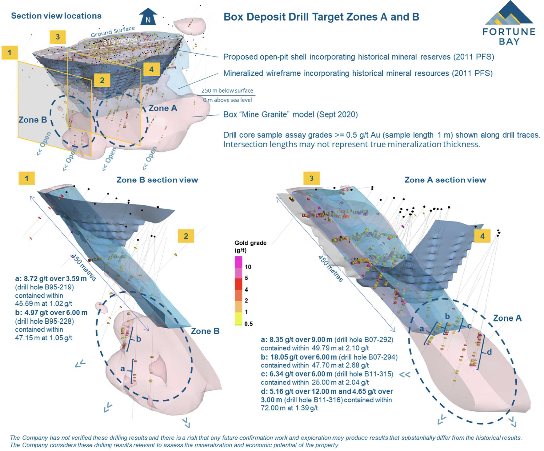
- Two priority higher-grade zones have been identified for drill targeting and resource expansion, Box Zone A and Box Zone B (Figure 2). Highlight gold results from historical drilling completed along these Zones outside of the boundaries of the 2011 mineral resource estimate include:
- Box Zone A:
- 18.05 g/t over 6.00 m (drill hole B07-294) contained within 47.70 m at 2.68 g/t
- 8.35 g/t over 9.00 m (drill hole B07-292) contained within 49.79 m at 2.10 g/t
- 6.34 g/t over 6.00 m (drill hole B11-315) contained within 25.00 m at 2.04 g/t
- 5.16 g/t over 12.00 m and 4.65 g/t over 3.00 m (drill hole B11-316) contained within 72.00 m at 1.39 g/t
- Box Zone B:
- 8.72 g/t over 3.59 m (drill hole B95-219) contained within 45.59 m at 1.02 g/t
- 4.97 g/t over 6.00 m (drill hole B95-228) contained within 47.15 m at 1.05 g/t
- Drill intersections are from exploration holes with spacings varying from 10 to 110 metres, approximate 45 metre average.
- Box Zone A:
- The higher-grade intersections are interpreted to potentially represent ore-shoots within a plunging extension of the Box “Mine Granite”, which is confirmed by these holes as being present and open with depth.
- Step-out drilling is planned both along strike and down-dip of the higher-grade drill intercepts in both zones with the objective of establishing continuity of high grades and expanding the mineral resources.
- Additional infill and delineation drilling is also planned at various locations to increase confidence with the intention of converting historical inferred mineral resources to an indicated level of confidence.
Athona Deposit
- The Athona deposit remains open to the south, beyond the extents of the mineral resources and reserves that were defined in the historical (2011) Pre-Feasibility Study.
- The Athona “Mine Granite” that hosts the gold mineralization extends southwards to and beyond the historical Number 2 shaft, where limited drill holes confirm the presence of significant gold mineralization.
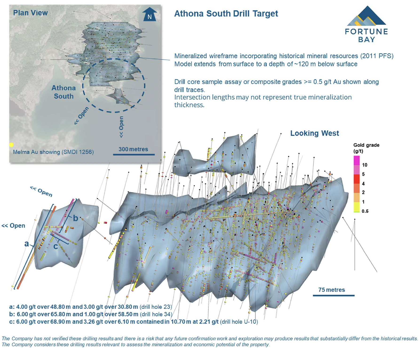
- Athona South has been selected as a priority zone for resource expansion (Figure 3). Underground and surface drilling in this area was carried out in the period 1935 to 1939. Gold samples from these holes were collected on an approximate 1.5 m spacing, however in certain instances only composited results for longer intervals are available. Selected highlight historical gold results from Athona South include:
- 4.00 g/t over 48.80 m and 3.00 g/t over 30.80 m (drill hole 23)
- 6.00 g/t over 65.80 m and 1.00 g/t over 58.50 m (drill hole 34)
- 6.00 g/t over 68.90 m and 3.26 g/t over 6.10 m contained in 10.70 m at 2.21 g/t (drill hole U-10)
- Planned drill testing at Athona South includes confirmatory drilling to verify these historical results, infill drilling to establish continuity with mineralization to the north, and step-out drilling southwards to define and extend mineral resources.
- Additional infill and delineation drilling is also planned at various select locations at Athona to increase confidence with the intention of converting historical inferred mineral resources to an indicated level of confidence.
Regional Potential
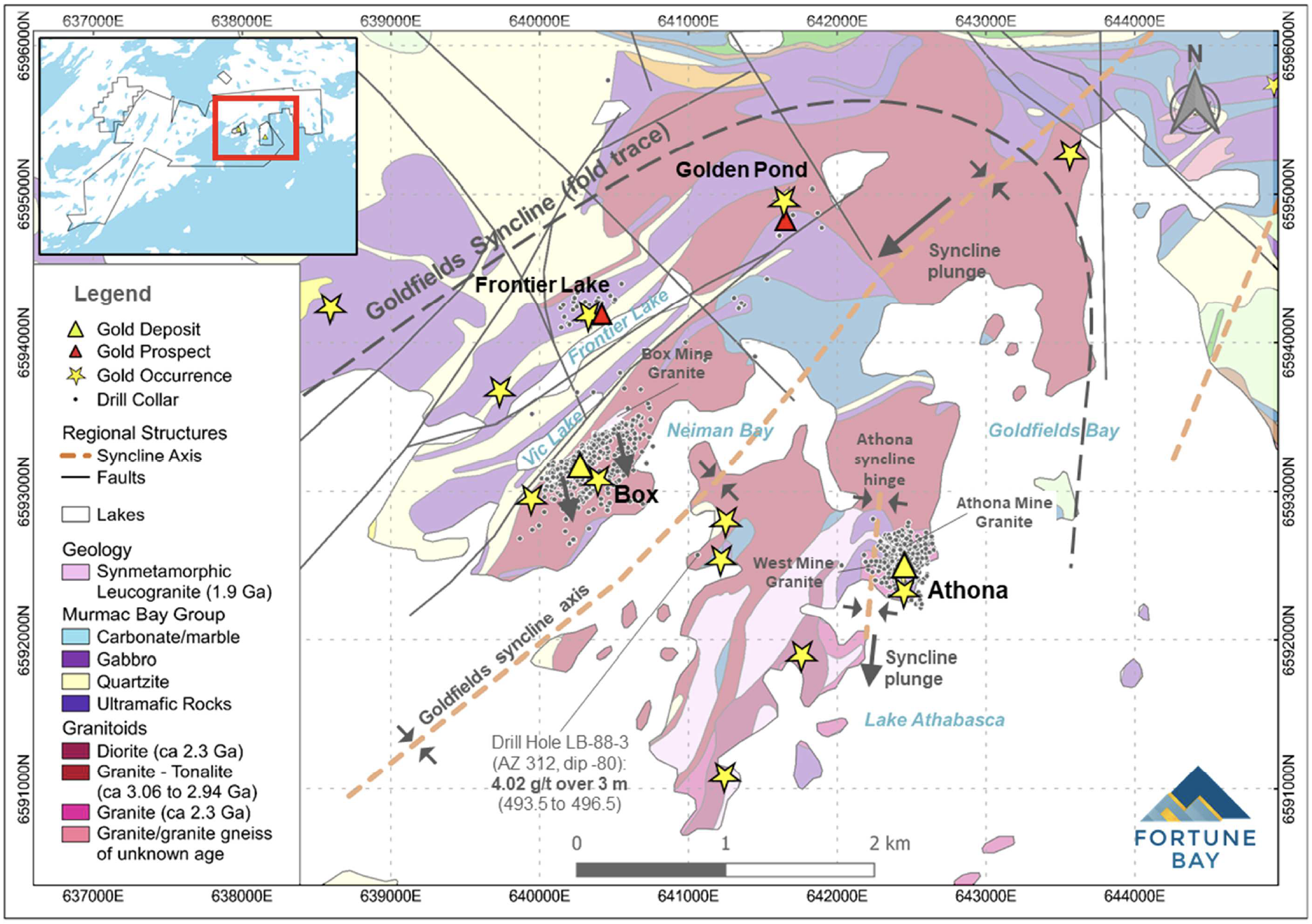
The Box and Athona gold deposits occur within the Goldfields Syncline – a major, open fold structure which plunges gently to the south within the Property (Figure 4). Box is located on the western limb of the structure and Athona within the hinge zone, occurring along the same stratigraphic contact. Gold mineralization at both deposits is associated with quartz veining hosted within granitic rocks, also referred to as “Mine Granites”. These granitic rocks are interpreted to have undergone brittle deformation during regional folding which allowed for the infiltration of hydrothermal fluids along fractures and the subsequent precipitation of quartz veins and gold.
Additional exploration potential exists within the Goldfields Syncline, to locate and explore additional Mine Granites that may have been subject to similar brittle deformation and gold mineralizing processes. In particular, areas that are covered by thin glacial tills and water bodies are considered unexplored to date. Other gold prospects on the property, including Frontier Lake, Golden Pond and Triangle, also show granitic associations and indicate potential for Mine Granites along other stratigraphic horizons.
Historical exploration has been primarily comprised of surface prospecting and outcrop sampling followed by drilling. Opportunity exists to make additional discoveries through systematic regional exploration using modern orogenic gold exploration methodologies, including high-resolution airborne surveying (magnetics and radiometrics) and appropriate soil sampling techniques.
Next Steps
An application for an 18-month drilling permit was submitted to the Government of Saskatchewan in mid-August, which is expected to be granted later this year following successful completion of the review and consultation process. Detailed planning for a drilling program is underway, following on from the operational assessment that was completed for the Project in September 2020.
Update on Mineral Resource Modelling and Estimation
As announced previously, an updated mineral resource estimate is planned before the end of the first quarter of 2021 to verify historical estimates and classify current mineral resources in accordance with NI 43-101. Work completed to date, following the September 2020 field program, includes verification of historical geological logs, sampling intervals and drill collar positions, and the transformation of the historic mine grid reference systems. Select relogging of historical drill cores is underway in support of the development of updated geological models. Work planned for October and November includes a repeat sampling program and petrographic analysis to verify historical assay results and refine understanding of the nature and distribution of the gold mineralization.
Data Verification and Qualified Person
The historical drill results contained within this news release have not been verified and there is a risk that any future confirmation work and exploration may produce results that substantially differ from the historical results. The Company considers these drilling results relevant to assess the mineralization and economic potential of the property. For historical drill holes 23 and 34 at the Athona deposit, only composited results are available in the historical dataset. These composited grades may reflect highly anomalous results in individual samples and should not be interpreted to imply that mineralization is continuous throughout the interval.
The technical and scientific information in this news release has been reviewed and approved by Dale Verran, M.Sc., P.Geo., Chief Executive Officer of the Company, who is a Qualified Person as defined by NI 43-101. Mr. Verran is an employee of Fortune Bay and is not independent of the Company under NI 43-101.
About Goldfields
The 100% owned Goldfields Project is the Company’s most advanced asset located in northern Saskatchewan, approximately 13 kilometres from Uranium City, for which a historical Pre-Feasibility Study (“2011 PFS”) was completed in October 2011 in accordance with NI 43-101. The 2011 PFS envisaged open-pit mining of the Box and Athona gold deposits, located two kilometres apart, over 13 years with estimated gold recoveries of 91% and 89% respectively, processed at a shared mill facility with a capacity of 5,000 tonnes per day. Economic highlights from the 2011 PFS include an NPV (at a 5% discount rate) of CAD$144.3 million (pre-tax) and a 19.6% IRR (pretax) using a base case of CAD$1,250/oz of gold (exchange rate CAD$ = 0.96 USD$). Total capital costs were estimated at CAD$159.2 million including a 13.7% contingency. Mineral reserve and mineral resource estimates for the 2011 PFS (Box and Athona deposits) included; 1.02 million ounces of gold (22.3 million tonnes at 1.4 g/t Au) in proven and probable reserves, 1.03 million ounces of gold (20.9 million tonnes at 1.5 g/t Au) in measured and indicated resources (included in the proven and probable reserves), and 0.23 million ounces of gold (4.6 million tonnes at 1.5 g/t Au) in inferred resources. The Project is endowed with established infrastructure including existing roads, powerline, and nearby facilities and an airport at Uranium City. Saskatchewan is the top ranked jurisdiction for mining in Canada according to the Fraser Institute Annual Survey of Mining Companies (2019), Investment Attractiveness Index. The Project has a history of gold production (64,000 oz Au produced between 1939 to 1942), numerous exploration drilling campaigns (~80,000 metres of drilling in ~675 drill holes) and various mining studies (including a 2007 Feasibility Study for the Box deposit for GLR Resources Inc. that was prepared in accordance with NI 43-101). The Box open-pit mine and mill development is permitted having received Ministerial approval under the Environmental Assessment Act in May 2008. The 10,300 hectare Goldfields property presents numerous exploration opportunities, including the potential to expand the Box and Athona deposits and discover additional resources at several other gold prospects and occurrences.
About Fortune Bay
Fortune Bay Corp. (TSXV:FOR) is a gold-focused exploration and development company with 100% ownership in two high-quality advanced gold projects in Canada, Saskatchewan (Goldfields Project) and Mexico, Chiapas (Ixhuatán Project), both with exploration and development potential. The Company has a goal of building a midtier gold exploration and development Company through the advancement of its existing projects and the strategic 4 acquisition of new projects to create a pipeline of growth opportunities. The Company’s corporate strategy is driven by a Board and Management team with a proven track record of discovery, project development and value creation. Further information on Fortune Bay and its assets can be found on the Company’s website at www.fortunebaycorp.com or by contacting us as info@fortunebaycorp.com or by telephone at 902-334-1919.
On behalf of Fortune Bay Corp.
”Dale Verran”
Chief Executive Officer
902-334-1919
Cautionary Statement Regarding Forward-Looking Information
Information set forth in this news release contains forward-looking statements that are based on assumptions as of the date of this news release. These statements reflect management's current estimates, beliefs, intentions and expectations. They are not guarantees of future performance. Fortune Bay Corp. (“Fortune Bay” or the “Company”) cautions that all forward-looking statements are inherently uncertain, and that actual performance may be affected by a number of material factors, many of which are beyond Fortune Bay's control. Such factors include, among other things: risks and uncertainties relating to metal prices, changes in planned work resulting from weather, logistical, technical or other factors, the possibility that results of work will not fulfill expectations and realize the perceived potential of Fortune Bay's mineral properties, uncertainties involved in the interpretation of drilling results and other tests, the possibility that required permits may not be obtained in a timely manner or at all, risk of accidents, equipment breakdowns or other unanticipated difficulties or interruptions, the possibility of cost overruns or unanticipated expenses in work programs, the risk of environmental contamination or damage resulting from the exploration operations, the need to comply with environmental and governmental regulations and the lack of availability of necessary capital, which may not be available to Fortune Bay, acceptable to it or at all. Fortune Bay is subject to the specific risks inherent in the mining business as well as general economic and business conditions. Accordingly, actual and future events, conditions and results may differ materially from the estimates, beliefs, intentions and expectations expressed or implied in the forward-looking information. Except as required under applicable securities legislation, Fortune Bay undertakes no obligation to publicly update or revise forward-looking information. Fortune Bay does not intend, and does not assume any obligation, to update these forward-looking statements, except as required under applicable securities legislation. For more information on Fortune Bay, readers should refer to Fortune Bay's website at www.fortunebaycorp.com.
Cautionary Note Regarding Historical Mineral Resource and Reserve Estimates and Historical Results
A Pre-Feasibility Study (the “2011 PFS Technical Report”), with an effective date of October 6, 2011, was completed for the Goldfields Project by March Consulting Associates Inc. in cooperation with Wardrop (now Tetra Tech), Dan Mackie Associates (DMA) and EHA Engineering Ltd. The mineral resources and mineral reserves were classified according to the CIM Standards on Mineral Resources and Reserves: Definitions and Guidelines, November 2005 (“CIM 2005”) and incorporated, by reference, into National Instrument 43-101 – Standards of Disclosure for Mineral Projects (“NI 43-101”). The 2011 PFS Technical Report was issued to Brigus Gold Corp. (“Brigus”), and subsequently re-issued to successor company, Fortune Bay on March 13, 2014. The full 2011 PFS Technical Report is filed on SEDAR (www.sedar.com) under Brigus’s issuer profile. The reader is cautioned that a Qualified Person has not done sufficient work to classify the mineral resources and mineral reserves stated in the 2011 PFS Technical Report as current resources and reserves. Fortune Bay is not treating this historical estimate as current mineral resources or reserves. While this estimate was prepared in accordance with NI 43-101 and CIM 2005 in effect at the time, there is no guarantee that it would be consistent with current standards and it should not be regarded as such. Fortune Bay has not undertaken any independent verification of the data upon which the historical estimates are based. The historical estimate is considered relevant to assess the mineralization and economic potential of the property. Historical results, including drilling results, have not been verified and there is a risk that any future confirmation work and exploration may produce results that substantially differ from the historical results. The Company considers these drilling results relevant to assess the mineralization and economic potential of the property.

Figure 1: Goldfields Project infrastructure and location map.

Figure 2: Box Deposit Drill Target Zones A and B.

Figure 3: Athona South Drill Target.

Figure 4: Geological map of the Goldfields Syncline.
Download Release