Project Highlights | |
|---|---|
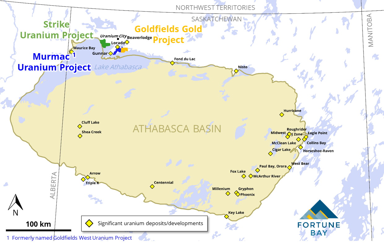
| Location | Northern Saskatchewan, Canada |
| Ownership | 100% |
| Status | Athabasca Basin uranium exploration project with +12 km strike of prospective EM conductors and uranium intercepts in first-pass drilling, including 0.43% U3O8 over 0.1 m. Under option to Aero Energy Ltd. |
| Commodity | Uranium |
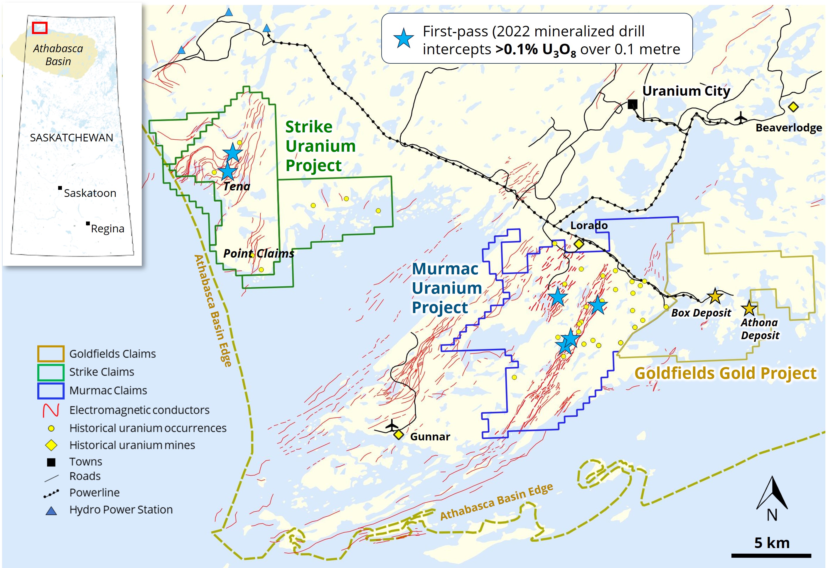
The 100% owned Strike Uranium Project has been confirmed to have potential for high-grade unconformity-related, basement-hosted uranium deposits in a setting similar to other discoveries on the margin of the Athabasca Basin.
Historical exploration by Cameo Corp. confirmed the presence of extensive EM conductors and significant U3O8 endowment at Strike, and provided high-quality VTEMTM and geochemical datasets. Drill targets were identified, but exploration was halted during the uranium price collapse of 2007/2008, and the ground was allowed to expire in 2012 post-Fukushima.
Fortune Bay augmented the historical datasets with ground gravity survey and completed a maiden drill program of 9 holes (2,064 m) in summer 2022. Anomalous uranium was intersected in three of the holes, up to a maximum individual assay of 0.43% U3O8. Shallow, elevated uranium in drill core is associated with “pathfinder” elements (typical of high-grade Athabasca deposits) and is hosted in prospective graphitic units with favorable brittle structure and alteration.
The drill results confirm that an Athabasca Basin unconformity-style mineralizing system has been active at Strike. Follow-up of newly intersected mineralization is warranted, as well as drill testing of numerous geophysical and structural targets.
Project Summary
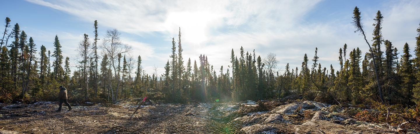
The Project covers an area of approximately 10,000 hectares and is located 25 kilometres west of Uranium City and the Company’s flagship Goldfields Project in northern Saskatchewan, and 15 kilometres southeast from Camsell Portage. Clean-energy hydro power stations are available within 10 kilometres of the Project to the north and regional airports are available at Uranium City and Camsell Portage. The Project is accessible year-round either by air (helicopter or fixed-wing), ice road (winter months) or boat/barge (summer months).
Exploration Potential – an Untested Exploration Model
The geological setting, historical datasets and current drill results support the Project’s potential for Athabasca Basin high-grade unconformity-related, basement-hosted uranium deposits in accordance with current exploration models for these types of deposits. Key exploration criteria identified include:
Known historical uranium endowment:
- Host to numerous high-grade (>1% U3O8) historical uranium occurrences.
- Anomalous radioactivity historically noted occurring in almost all basement lithological units on the property.
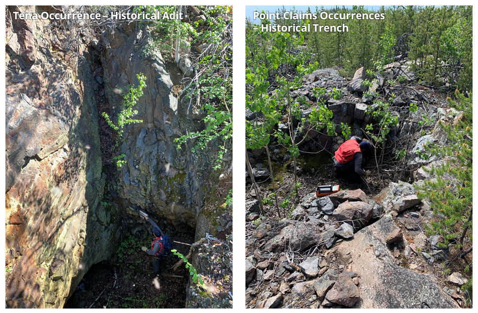
- Historical small-scale mining at the Tena Zone - over 1,000 tons mined in the 1950’s with reported grades of 0.5% to 3% U (0.6% to 3.5% U3O8).
Favourable geological setting:
- Multiple highly-graphitic and sulphide-rich units with favorable alteration and brittle structures, occurring over a total strike length of approximately 12 kilometres, represented by strong electromagnetic (“EM”) conductors in geophysical datasets.
- These prospective units are soft and weather preferentially, forming pronounced negative topographical features (valleys) infilled with cover sediments and lakes. They are not visible at surface and have not previously been directly prospected or drill tested.
- Folding of the Zemlak Domain metasedimentary package, including bends and jogs, provide prospective dilational settings.
- The present-day Athabasca Basin margin is located immediately west of the Project, indicating vertical proximity to the Basin’s basal unconformity (now eroded) and confirming good preservation potential for basement-hosted mineralization.
Indicative alteration and geochemical pathfinder signatures:
- Historical rock sampling and current drill results confirm:
- Presence of indicative alteration minerals (chlorite, illite, kaolinite, and hematite) and bleaching within graphitic units.
- Anomalous uranium and geochemical pathfinder signatures (boron, vanadium, cobalt, nickel, copper, lead, molybdenum, zinc, silver and arsenic).
Project History
The historical exploration information presented here has been compiled from reports obtained from the Saskatchewan Mineral Assessment Database, please review the Technical Disclosure section at the bottom of this page for more information and cautionary notes.
The first recorded uranium exploration in the area was carried out during the 1950’s. This initial work consisted primarily of prospecting and trenching, and numerous uranium occurrences were discovered. One of these occurrences, known as the Tena Zone, was mined on a small-scale during the late 1950’s, with ore shipped to the Lorado mill for processing. During the late 1960’s and early 1980’s, SMDC (now Cameco Corp.), Mokta and Jodi Energy Resources Ltd. completed more comprehensive work consisting of airborne magnetic and electromagnetic (“EM”) surveys with follow up ground EM surveying. Although these EM surveys did detect a significant number of ground EM conductors along the edge of the Athabasca Basin, diamond drill testing was very limited. Assessment records indicate that only seven drill holes have been completed on the property to date. Three of the holes are located near the Tena Zone with one hole intersecting 1.6% eU over 4 feet (eU is equivalent uranium derived from a downhole gamma spectrometer). The other four holes are located at the Point Claims on the southeast side of the Project.
Work carried out by Cameco Corp. (“Cameco”) between 2005 and 2008 produced several high-quality datasets including airborne magnetic and electromagnetic surveys (VTEMTM), ground electromagnetic surveys (Max-Min and Step-Wise Moving Loop), and outcrop geochemical and reflectance spectrometry (clay) sampling programs. Cameco did not conduct any drilling on the project, and despite definition of drill targets and recommendations to advance the project, the ground lapsed in 2012 (soon after the 2011 Fukushima nuclear accident). These publicly available datasets acquired by Cameco represent a valuable repository of data for the Project to support drill targeting, augmented by more recent work by Fortune Bay (below).
Work Completed by Fortune Bay
Verification Field Prospecting and Sampling
In June 2021 Fortune Bay verified the Tena Zone and Point Claims occurrence through geological investigation and confirmatory surface rock sampling. The results demonstrated high uranium grades (up to 3.51% U3O8) on surface together with anomalous geochemical associations indicative of unconformity-related, basement-hosted uranium mineralization.
Ground Gravity Survey
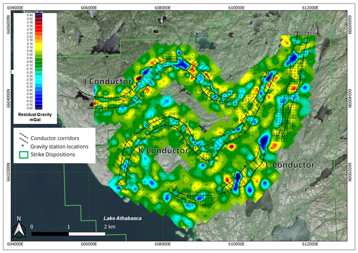
In early 2022, Fortune Bay commissioned a ground gravity survey by MWH Geo-Surveys of Vernon, BC, to obtain high-resolution coverage of the extents of the three major EM conductors (from northwest to southeast, named “J”, “K” and “L”) identified for targeting in the northwest extent of the license area. A total of 2,073 stations were collected with varying survey line orientation to best evaluate the targeted conductors. The resultant survey data are shown in the figure below. Multiple high-amplitude gravity lows (potential clay alteration zones) are present, and the results also provide valuable structural information confirming the presence of major lineaments noted in satellite photography and magnetic/EM datasets.
Core Drilling
Targeting criteria for drilling in 2022 included follow-up at the historical Tena occurrence (2 holes), and exploration targeting of a variety of geophysical and structural features to test targets present on all three of the EM conductors, which had never previously been drilled. A total of 9 holes (2,064 m) were completed, 220 drill core samples were sent to the Saskatchewan Research Council for analysis, and 248 chip samples were analysed for clay species by clay reflectance spectroscopy (PIMA).
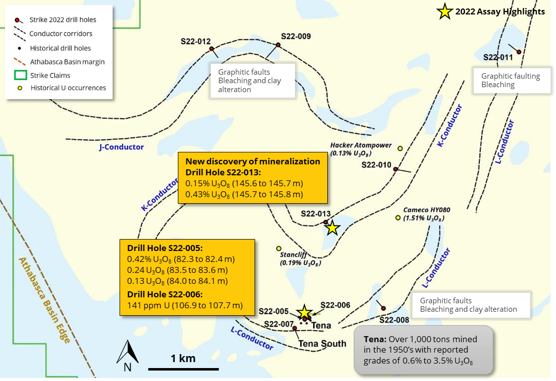
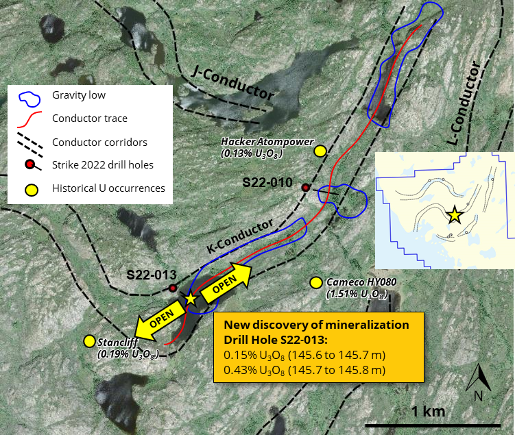
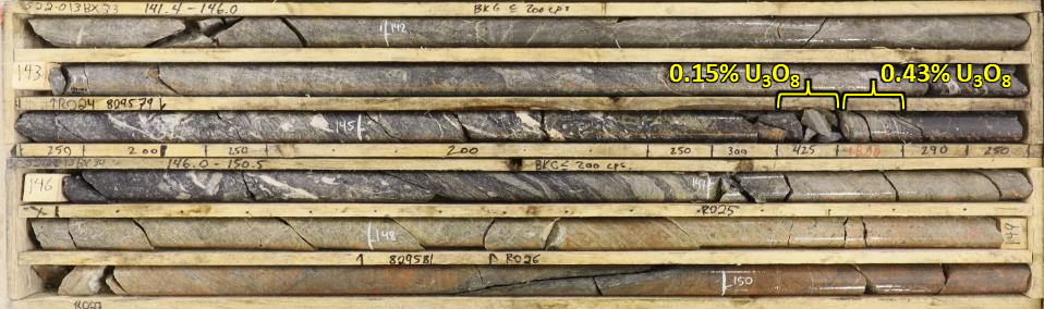
Drill hole S22-013, testing a gravity low / fault intersection with the K Conductor, discovered new mineralization (up to 0.43% U3O8 over 0.1 m from 145.6 to 145.7 m) associated with reactivated structures in bleached graphitic rocks and pathfinder element enrichment.
The targeted mineralized structure at Tena was intersected at depth by both holes at this location. Intercepts included:
- S22-005: 0.42% U3O8 (82.3 to 82.4 m), 0.24% U3O8 (83.5 to 83.6 m) and 0.13% U3O8 (84 to 84.1 m).
- S22-006: 141 ppm U (106.9 to 107.7 m)
This 2022 first-pass drill testing in the northern part of the property intersected elevated uranium mineralization (>100 ppm U) in four of nine holes completed. All of these intersections are shallow, derived from between 60 and 105 m vertically below surface.
All holes intersected favorable graphitic units with faulting, variable bleaching and alteration, and indicative clay species (illite, chlorite and kaolinite). Elevated uranium is associated with enriched "pathfinder" elements, and other intersections with pathfinder elements of interest are present without elevated uranium, indicating other potential targets for follow-up.
Future Drilling
Follow-up drill testing along strike of S22-013 on the K Conductor is warranted to test for higher-grade and thicker mineralization, given the highly favorable geological setting. Numerous other geophysical and structural targets warrant drill testing along the J, K and L Conductors.
Sampling, Analysis and Data Verification
All samples were submitted to the Saskatchewan Research Council (“SRC”) Geoanalytical Laboratories (ISO/IEC 17025:2005 accredited) for multi-element characterization and uranium assay. Samples are screened upon receipt by SRC, and samples with significantly elevated radioactivity were identified and separated out for the SRC “ICP1” multi-element uranium exploration package. Analysis of the remaining samples was carried out through the SRC “ICP-MS2” basement exploration package. Sample preparation for all samples included drying, jaw crushing to 60% passing -2 mm, and pulverizing to 90% passing -106 microns.
The ICP1 package includes ICP-OES on a total digestion. The ICP-MS2 package consists of three separate analyses, including (1) ICP-MS on a partial digestion, (2) ICP-OES for major and minor elements on a total digestion and (3) and ICP-MS analysis for trace elements on the total digestion. Partial digestions are performed on an aliquot of sample pulp, which is digested in a mixture of concentrated nitric: hydrochloric acid (HNO3:HCl) in a test tube in a hot water bath, and then diluted using deionized water. Total digestions are performed on an aliquot of sample pulp. The aliquot is digested to dryness in a Teflon tube within a hot block digestion system using a mixture of concentrated HF:HNO3:HCIO4. The residue is dissolved in dilute HNO3. Additional analysis for Boron content was obtained for all samples through NaO2/NaCO3 fusion followed by ICP-OES.
QAQC for sample processing included insertion of Blank certified reference material (“CRM”) samples by Fortune Bay at a rate of 1 for every 20 samples, as well as an internal QAQC process by SRC, including regular repeat analyses and insertion of CRM multi-element, uranium and boron standards. All QAQC results were reviewed by Fortune Bay and are considered to confirm that the analyses are of high quality and are sufficiently well constrained to use for the purpose of exploration.
Technical Disclosure
The historical exploration information presented here has been compiled from reports obtained from the Saskatchewan Mineral Assessment Database. Unless otherwise stated, the historical results have not been verified and there is a risk that any future confirmation work and exploration may produce results that substantially differ from the historical results. The Company considers these results relevant to assess the mineralization and economic potential of the property.
Qualified Person
The technical and scientific information on this webpage has been reviewed and approved by Gareth Garlick, P.Geo., Technical Director of the Company, who is a Qualified Person as defined by NI 43-101. Mr. Garlick is an employee of Fortune Bay and is not independent of the Company under NI 43-101.
Cautionary Statements
Information set forth on this webpage may contain forward-looking statements that are based on assumptions as of the date of posting. The reader is referred to the cautionary language contained within the respective Project’s News Releases, in addition to this website’s Terms of Use specifically including Forward Looking Statements.